 Shey Phoksundo National Park, Phoksundo Lake, Numala Pass, Shey Gompa, the Buddhist monasteries, pristine mountains, Flora & Fauna
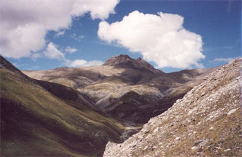
Shey Phoksundo National Park (3555 sq km) of mid-western Nepal is focal point of Upper Dolpo, behind the Mount Dhaulagiri massif, towards the Tibetan Plateau. The part provides good habitat for snow leopard, blue sheep, Ghoral, Himalayan Black Beer etc... This rugged and remote Dolpo region remains a truly isolated corner of Nepal.
Unlike rest parts of Nepal, Dolpo area, shadowed from seasonal rain, is hard to match for its surreal beauty and stunning charm, no where to be found. There we can find many cultural, religious and social life similarities between Upper Dolpo and Tibet. This region is thinly vegetated, dry and only fewer settlements are seen here, but a thrilling hardcore landscape, guarded by pristine snowy peaks. Other remarkable objects seen here are ancients and isolated villages, immortal to time, fabulous lakes, authentic Buddhist monasteries and abundant wildlife etc.
TREKKING SEASONS
Since much of Dolpo rests in the rain shadow cast by Dhaulagiri, effects of the monsoon are not as extreme as experienced further east. It is therefore possible to trek there during the summer, as well as in the normal pre-and post-monsoon trekking seasons. Problems are likely to be encountered, however, in travel to and from the region during the monsoon months. Winters are notoriously cold and with very heavy snowfalls, so November through till spring should be avoided. During these months Dolpo is often cut off from the rest of Nepal. Trekking in Dolpo is possible mainly during the months of May, June, July, August, September and October.
Day 01 Your arrival to Tribhuwan International Airport (TIA), Kathmandu (1350m), Nepal
You will be met by our Airport Representative, and transfer to hotel. Overnight at hotel, inclusive of breakfast.
Day 02 today you will take full day guided tour of Kathmandu valley including Pashupatinath Temple, Boudhanath, Swayambhu, and Kathmandu durbar square. Overnight at hotel, inclusive of breakfast.
Day 03 Flight From Kathmandu to Nepalgunj (150m).
Today you will take 1 hour flight (with good view of the Himalayas to the north) from Kathmandu to Nepalgunj. Upon arrival at Nepalgunj Airport, you will be picked up by one of our staffs and transfer to hotel Batika or similar.
Overnight at hotel, inclusive of full board meal.
Day 04 Flight From Nepalgunj to Juphal Then Trek to Dunai (2109m).
The flight to Dolpo from Nepalgunj is short but exciting, and the landing a heart-stopping affair typical of so many grass-strip landings in upcountry Nepal. The Juphal airport is on a hillside shelf high above the river at an altitude of 2354m., with the few houses of the village tucked just below overlooking the deep Thuli Bheri valley. Upon arrival at Juphal, you will meet our support staffs of the trek and start the first day journey to Dunai (3 hours walking). Dunai is district headquarter of Dolpo which is situated at elevation of 2109 above the sea level. It is a large village with paved street lined with houses, several shops and some lodges. The village has a school, police check-post and government office.
Overnight at tented camp, inclusive of full board meal.
Day 05 Trek to Hanke (2660m).
Today you will trek about 6-7 hours to reach Hanke. You will follow the route of the confluence of the Thuri Bheri and Suli Gad rivers and turn to the north and follow the Suli Gad river. The trail is fairly undulating and you are never faraway from the river and its roar. You also walk through some nice villages such as Parela meaning eyelash, Rahagaon meaning eyebrow, and Ankhe meaning eye. Eventually, you will arrive at Hanke, which is also the entry point of Shey Phoksundo National Park.
Overnight at tented camp, inclusive of full board meal.
Day 06 Trek to Renje (3104m).
The trail starts becoming very hectic but once you cross the river twice on well made bridges, you then make a steep ascent on a very narrow path hugging the cliff face. Having descended to the river again the trail takes another steep ascent requiring frequent stops to watch the panorama of the landscapes and also for some rest. You may camp on the side of Suligad River .
Overnight at tented camp, inclusive of full board meal.
Day 07 Trek to Shey Phoksundo Lake (3738m).
It is about 6-7 hours walking to Shey Phoksundo Lake from Sumdo. The trek from here is steeply uphill. Here you will leave the river and follow the path high above the water. You will ascend to a ridge (about 3900m) from where you can see amazing views of a waterfall, and your first view of Phoksundo Lake. You then descend through birch forests to the picturesque settlement of Ringmo village with its chortens and mani walls. It is just a short walk to the shores of Phoksundo lake where is your tonight's camp.
Overnight at tented camp, inclusive of full board meal.
Day 08 Rest Day. Explore Day!!!
Today we rest to admire the beauty of this great lake. We also visit nearby villages inhabited by Bon and Buddhist Settlers.
Overnight at tented camp, inclusive of full board meal.
Day 09 Trek to Phoksundo Khola (3500m). 5-6 hrs walking.
From the lakeside you follow the trail that skirts the edge of the lake itself. This precarious trail is suspended on a gangway of wood supported on pegs driven into crevices in the rocks and signals the remoteness of the area you are about to enter. You go very steeply up, to 4,040m, and then plunge down again to the valley bottom to enter the flood plain of the Phoksundo Khola and trek to your night stop alongside the river, but within the confines of the forest to avoid the worst of the wind which is prevalent in the valley bottom.
Overnight at tented camp, inclusive of full board meal.
Day 10 Trek to Phoksundo Bhanjyang (4400m) - 7-8 hrs walking.
There are quite a few stream crossings today, so you should take sandals or footwear suitable for knee deep crossings. This morning you continue along the level path through a glacial valley that now heads due north. As this becomes narrower and narrower there are impressive vertical cliffs and contorted rock formations. At the confluence of the Phoksundo Khola and another, unnamed, mountain stream there is an old wooden bridge. Here you take the barely discernible path to the north east up a side valley which has a cavernous look. There is no trail as such, so it is necessary to clamber over rocks and boulders and to ford a stream that rushes down the steep valley. A long climb brings you to a sheep meadow where the trail veers up a steep ravine. A hard climb to the top brings you to yet another valley where you can see the Kang La, the pass will lead you to Shey Gompa. You camp just before the pass in a place that Peter Matthiessen christened 'Snowfields Camp'.
Overnight at tented camp, inclusive of full board meal.
Day 11 Cross the Kang La (5150m), Then trek to Shey Gompa (4126m). 6-7 hrs walking.
After an initial easy stretch going up the flood plain, the trail goes up very steeply. The somewhat indistinct track is physically demanding especially on the loose slate scree. It will take about two and a half to three hours to reach the top of the Kang La. The views from the top however are magnificent and well worth all the hard work. The height of the Kang La is variously given between 5,200 and 5,500 metres depending on the map one uses. On descending steeply to the valley floor, not more than 45 minutes, you make a long meandering trek along the banks of the river, crossing it once. A red chorten heralds your arrival at Shey Gompa where a quaint wooden log bridge leads up to the Shey compound.
Overnight at tented camp, inclusive of full board meal.
Day 12 Rest Day At Shey Gompa.
As Shey means crystal, this monastery is also known as the Crystal Mountain . The lama of Shey resides at a red hermitage known as Tsakang gompa which is west of Shey. It is not really a monastery but a retreat. Tsakang had been a meditation centre of many famous lamas from Tibet. Shey Gompa belongs to the Chaiba community, followers of the Padmasambhava and Kagyu sects. It was the first Kagyupa monastery and its founder was the lama Ten-szin-Ra-Pa. The monastery was built during the 11th century. Shey is famous for its ancient Buddhist culture. In Dolpo the ancient Tibetan way of life combines animism with the teachings of Buddha. Drutup Yeshe introduced Buddhism in the Dolpo valley. Many years ago he came to Dolpo and came across a wild people whose supreme God was a 'fierce mountain spirit'. Crystal mountain is to the west of Shey monastery. It is a very strange mountain indeed. Its contorted cliffs are laced with quartz and embedded with a rich variety of marine fossils. Shey Gompa stands above the confluence of Kangju nala and Yeju nala. Near the confluence there is a group of prayer mills turned by water wheels.
Overnight at tented camp, inclusive of full board meal.
Day 13 Cross the Saldang La (4785m), Then trek to Namduna Gaon (4400m). 7 hrs walking.
You start by following a pleasant track amidst juniper, which ascends to a grey, stony canyon. This then begins to zig-zag over bare rocks and coarse eroded soil until it eventually brings you to a flat spot suitable for a brew or lunch if the weather is fine. You then continue very steeply up for 20 minutes before traversing to the top of the Saldang La. Here you can enjoy great views towards the arid landscapes of Mustang and the distant snow peaks of Tibet . The subsequent descent towards the north is long and tiring but you finally come upon the welcome sight of pastures of grazing yaks and sheep and nomadic tents made from yak hair. This signals your approach to Namduna Gaon. Like Shey, the Namgung monastery is of the Karma-pa sect. The monastery, a red stone structure, is built against the backdrop of a cliff on the north wall of a gorge. The red and white colours of the gompa and its stupas are the only colour in this stark landscape. The village itself consists of only six stone houses and has terraced fields on both sides of the tributary, which flow down to the Nam Khong valley. The economy of the region is based on agriculture, animal husbandry and trading. In Dolpo only one crop a year can be grown and this is mainly barley. In some villages buckwheat, oilseed, potato and radish are also cultivated. Recently the main cliff temple collapsed and the villagers have now built a beautiful new monastery in the village itself.
Overnight at tented camp, inclusive of full board meal.
Day 14 Trek to Saldang. (3900m). 3 hrs walking.
In the morning after packing up the loads you leave the Namgung monastery and start climbing a scree slope. Further on it begins a long thrilling traverse along some dusty barren mountains. Looking down into the valley bottom it is very evident that the people have made best use of the fertile valley as one sees the neat terraced fields showing bright patches of green and ripening crops. You ascend to 4700m before going down steep slopes to the picturesque village of Salding , situated on a plateau high above the Nam Khong nala and the biggest village of the inner Dolpo area. Though the village lies at about the same altitude as Ringmo it is totally different. Ringmo, a Himalayan village is situated below the tree line while Saldang belongs to the arid zone of the trans-Himalayan Tibetan plateau. The village stretches for two kilometres on an open slope and consists of five villages having eighty well-built houses with nearly six hundred villagers. It is prosperous, not only agriculturally, but also for its strategic location on a trade route to Tibet . After the Chinese occupation of Tibet in 1959, trade with Tibet was virtually stopped. It has been restored to some extent through the barter system by which Tibetan salt reaches mid-Nepal. The Drokpa people from the western plains of Tibet collect salt from the dried lakes north of Tsangpo.
Overnight at tented camp, inclusive of full board meal.
Day 15 Trek to Sibu. (4000m). 6 hrs walking.
You bid farewell to Saldang and on the way down to the river bed you pass through terraced fields, stupas, chortens, heaps of mani stones and a Chaiba monastery. Namdo, the next village is also prosperous with sixty houses having nearly four hundred inhabitants. It stretches for more than 5km on the high slopes to the left of Nam Khong Khola. The Namdo monastery is located near the river bed. There is also another monastery on top of a high cliff. You camp near the small settlement of Sibu, right on the river bank.
Overnight at tented camp, inclusive of full board meal.
Day 16 Trek to Foot Of The Jeng La. (4480m). 4-5 hrs walking.
Following the line of the river valley the trail is fairly easy-going initially. After about two hours it is necessary to wade another stream before turning into a side valley where the rise becomes very sharp. After only four hours walking you reach your lunch and night stop. This is a pleasant meadow, but bestrewn with rocks, yak and other animal droppings.
Overnight at tented camp, inclusive of full board meal.
Day 17 Cross The Jeng La, (4850m), Trek to tokyu Gaon (4240m). 6-7 hrs walking.
It is only a 2 hour climb to reach the top of the Jeng La. The trail is generally well-compacted making the going underfoot easy, much easier than loose shale, but it is steep. From the top of the pass there are good views of the Dhaulagiri massif, glittering in the morning light. A rough track descends towards the Tarap valley. By the afternoon you find a green valley which leads you by a pleasant track down towards the Tarap Chu. Tarap is a dream valley with vast plains in high mountains extending 20kms along the river Tarap Chu. It has ten villages with cultivated fields, many gompas and chortens of both sects. You halt for the night at tokyu monastery. This monastery also belongs to the Chaiba sect.
Overnight at tented camp, inclusive of full board meal.
Day 18 Trek to Dho Tarap. (4100m). 2 hrs walking.
You walk east along the downward course of Tarap Chu in a plain valley with patches of lush verdant grass on both sides of the river - completely different from other parts of inner Dolpo. Before leaving tokyu a short visit can be made to the Chaiba Gompa. The trail is broad and welltravelled, making the going easy and there is much evidence of work in the fields where the women will be bringing in the harvest – the men are away bringing down the herds of animals for the forthcoming winter. There are many mani walls but some of the chortens are in a bad state of repair. The ‘French School' is just outside the village of Dho Tarap where you have your night stop. Dho is surrounded by an irregular stone wall and consists of thirty-four houses, divided into three clusters and built in a haphazard way. A chance to make friends with the people from Dolpo. Tarap is inhabited mostly by Magars who have lived here for generations but also by a few Tibetans. They wear home-spun clothing that is sometimes dyed maroon and they favour Tibetan style somba (boots with upturned toes) for footgear. Men and women often wear both religious amulets and strings of coral and turquoise.
The inhabitants of this village are both Bon Po and Buddhist (Nyingmapa). In the afternoon a walk up to the Buddhist Gompa is very worthwhile. There is a resident lama who is very happy to show off his monastery and might even let you see his private Gompa and the tankas he has made himself. The Bon Gompa is about half an hour's walk.
Overnight at tented camp, inclusive of full board meal.
Day 19 Trek to Serkam (3630ft). 7 hrs walking.
The next two days are longish with a choice of several different campsites so the itinerary can be flexible. Your route follows the course of the Tarap Khola, generally downhill. You go through narrow gorges with the river rushing through. One may see blue sheep, marmots, yaks, sheep and goats and perhaps meet people from Dolpo taking their flocks of sheep and goats to lower pastures for the winter. The afternoon brings more undulations in the path when it leaves the immediate course of the river. There is evidence of improvements to the trail where parts of the rock have been blasted out. You will also see the first of the modern steel suspension bridges which have been built to facilitate movement of people and animals. The track is very narrow in places.
Overnight at tented camp, inclusive of full board meal.
Day 20 Trek to Khanigaon. (2550m). 6-7 hrs walking.
You continue to walk down the gorge of the Tarap River , sometimes high above, on a narrow trail built out from the steep slopes. The quality of the path varies from broad, smooth and firm to very narrow and crumbly. There are also flights of man- made stone staircases which need to be tackled with care – some of the constituent rocks wobble when stepped upon! An exciting day in deep and awe-inspiring gorges. Your camp site is a pleasant meadow in the shade of a stand of trees.
Overnight at tented camp, inclusive of full board meal.
Day 21 Trek to Tarakot. (2280m). 4 hrs. walking.
You leave Khanigoan by the new suspension bridge and then walk alongside the river, sometimes going very high before reaching down to the water again. Some of the going is quite demanding and one bridge, said to have unusable for six years, necessitates crossing on wet stepping-stones.
Coming into the broad fertile valley of the Barbung Chu, you walk amongst the various crops of millet, sweet corn, barley, buckwheat, green beans, chillies and marijuana. Your lunch and night stop is high above the river but there is a standpipe for water. Tarakot is an old fortress town known by the local people as Dzong, meaning 'fort'. Before the Gorkha dynasty Tarakot was the capital and had a dzong. The famous Sandul gompa, which lies 8km east of Tarakot and at the junction of Barbung Khola and Tarap Chu, stands on a knoll to the south of Bheri River and at one time supervised collections of tolls for the trading caravans traversing an area called Tichu Rong. As an alternative to camping at Tarakot, you may camp down by the river as there are good cooking facilities there and a clean, locked toilet for trekkers' use.
Overnight at tented camp, inclusive of full board meal.
Day 22 Trek to Dunai. (2109m). 5 hrs walking.
The trail is mostly down and fairly firm underfoot. Walking beside the Bheri River you use the ingenious path built twenty feet above the river. All too soon you have reached the village of Dunai and the camp site you used before. You will now have completed the circuit and can mark the occasion with a celebration party!
Overnight at tented camp, inclusive of full board meal.
Day 23 Trek to Juphal. (2404m). 3 hrs walking.
You now retrace your steps to Juphal. Initially the way is flat but the final hour up to your destination seems steeper than you remember on Day One! Camp overnight in the grounds of one of the lodges.
Overnight at tented camp, inclusive of full board meal.
Day 24 Fly to Kathmandu Via Nepalganj
Early morning flight to Nepalganj. This is a wonderful 35- minute flight over the Himalayan foothills, with fine views of the main peaks including Annapurna and Dhaulagiri to the north. You then connect with the flight back to Kathmandu.
Overnight at hotel, inclusive of breakfast.
Day 25 At Leisure In Kathmandu.
Overnight at hotel, inclusive of breakfast.
Day 26 Departure to Your Onward Destination
Transfer to the airport for your onward journey. Farewell!
All at highly competitive prices: - Please contact us for very special Price:-
17 Days Rara Lake Trek
16 Days Upper Mustang Trek
10 Days Doplo & Shey Phoksundo Lake Trek
26 Days Upper Dolpo Trek
22 Days Manaslu Trek
20 Days Pike Peak + Dudh Kunda Trek
21 Days Rowaling Valley Trek
22 Days Kanchenjanga Trek
21 Days Ganesh Himal Trek
24 Days Makalu Base Camp Trek
10 Days Bhairav Kunda Lake Trek
17 Days Tsum Valley Trek
If your answer is yes, there are many options and choices to extend your holiday before or after your main trip. Following trips are suggested for your holiday extensions.
Adrift Adventures Pvt. Ltd.
P. O. Box.: 19538, Thamel, Kathmandu , Nepal
Tel.: +977-1-4255715 / 4255702
Fax: +977-1-4255702
Cell: +977-9851004814 (24 hrs), 9779841437968(SMS)
Email: adrift@nepalriver.com,
adrift.inquiry@gmail.com
We are affiliated to
![]()
![]()
![]()
![]()
![]()
Copyright © Adrift Adventures - 2009
All right reserved.
Design by: Nepal Media